

Handheld GPS devices have been around for over 30 years now. If you have one but don’t use it for sailing or if you’d like to try using a GPS but don’t want to buy a more expensive, dedicated, marine GPS, then this is the article for you. I’ll share some of the tips and tricks that I use with my 20-year-old Garmin eTrex H to help me sail better. And I’ll show you free software that you can use to visualize your GPS data.
Before I continue, a bit of legal housekeeping. This post contains affiliate links. That means I receive a small commission if you make a purchase using those links. Those commissions help to pay the costs associated with running this site so that it stays free for everyone to enjoy. For a complete explanation of why I’m telling you this and how you can support this blog without paying more, please read my full disclosure.
I bought my used GPS many years ago on eBay for $50. It’s served me well on many mountaineering trips and it works just as well on the water. Don’t fall for the hype that you need a specific type of GPS for each sport or purpose.
All GPS devices do pretty much the same things. Some have extra features that can be convenient for specific activities but they’re not necessary for basic functionality. For example, besides the standard features, an automotive GPS can give you turn by turn directions to an address or allow you to find nearby points of interest. Besides the standard features, a hiking or running GPS might monitor the rate of your heartbeat and display your rate of ascent in elevation. Many popular marine GPS units show your position on a scrolling map and the current water depth as sensed from a hull mounted transducer.
However, you should never rely on any GPS as a substitute for a good map, compass, and the knowledge of how to use them. Electronics fail, batteries die, satellite signals get blocked. GPS technology has important limitations as the crew of the Vestas Wind was painfully reminded of in Volvo Ocean Race 2014. You can use a map and compass almost anywhere and anytime.
Among other things, you can use a handheld GPS to:
- Create waypoints to help you navigate
- Plan routes to help you get to where you want to go
- Monitor current speed, heading, and position
- Create tracks of where you’ve been that you can analyze later
I’m not going to go into the details of how to use a particular GPS device. Each manufacturer’s devices work different from the others and you can learn the basics from their documentation. What I will go into is some ways that you can use almost any GPS to become a better skipper.
Let’s start with the basics.
Know where you are and where you’re going
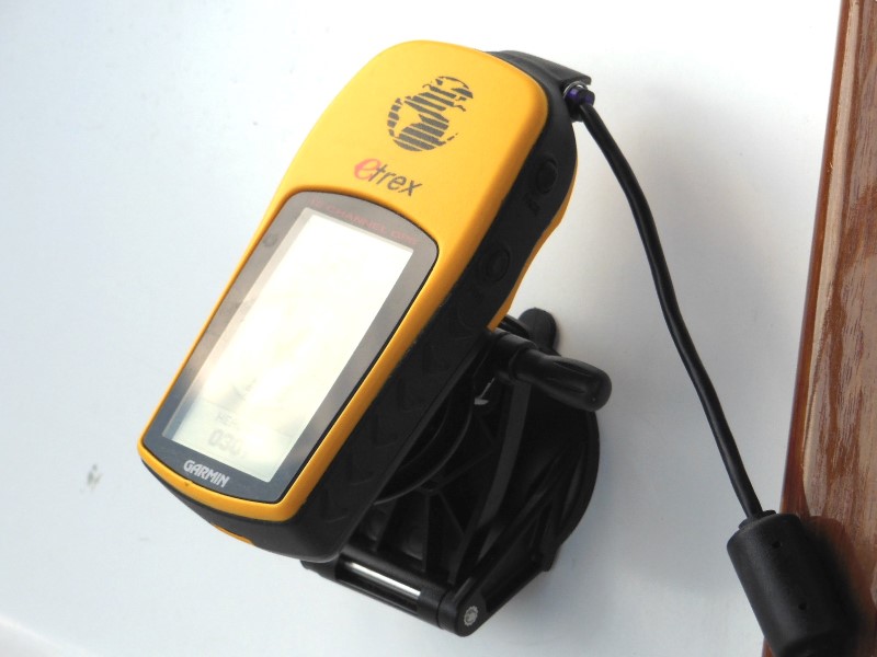
Until I installed a Garmin chartplotter, I used a handheld GPS all of the time on my sailboat. I mount it on the cockpit bulkhead beside the companionway. That makes it easy to see and it’s out of the way of crew and running rigging most of the time. I power my GPS with the house battery through an accessory panel that I mounted inside the companionway as described in How to Completely Rewire Your Sailboat.
Once it’s turned on and has acquired enough satellite signals to triangulate your location, it begins to show its current position in latitude and longitude. You can use those numbers to find your exact position on a map that has grid lines. Besides your location, a GPS can show you much more useful information.
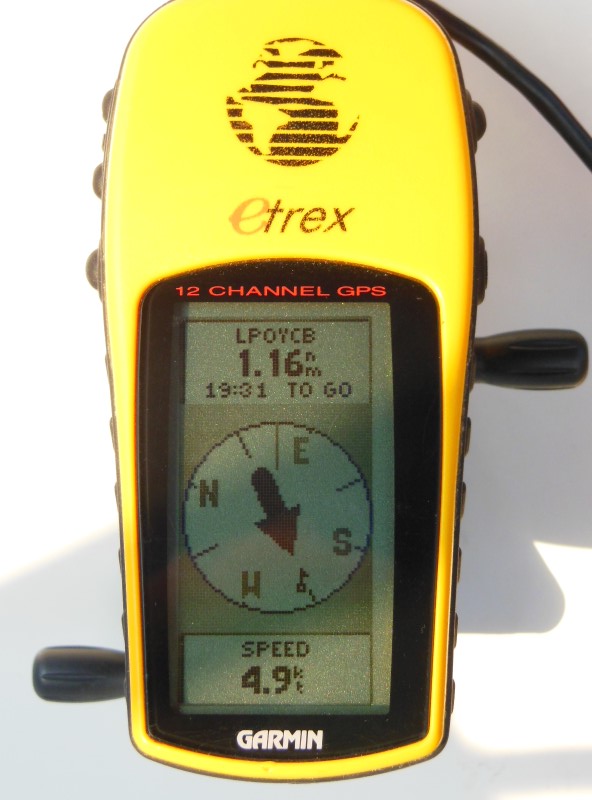
In the picture below, you can see that I’m making 4.9 knots of speed over ground. You can also see that I’m pointed almost due East (the GPS is pointed toward the bow). The waypoint labeled LPOYCB is 1.16 nautical miles away and would take 19 minutes and 31 seconds to reach at the current speed. Since the arrow is pointing almost behind me, I would have to turn around to go to the waypoint.
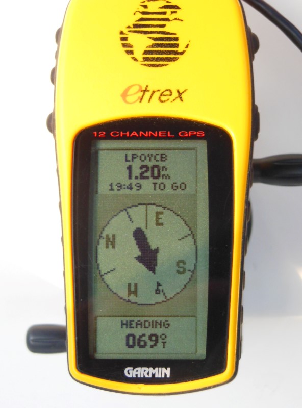
With the push of a button, you can switch the display from SPEED to HEADING. In the picture below, I’m heading 69 degrees relative to true North. Other readouts that are standard on most GPS devices are: BEARING to the current waypoint, LOCATION in latitude and longitude, MAX SPEED, AVG SPEED, SUNRISE, SUNSET, ELEVATION, TRIP TIME, and TRIP ODOMETER.
That’s a lot of good information to know. By monitoring my speed to the tenths of knots, I can immediately see the effect of sail trim adjustments. By knowing my minimum tacking and gybing angles, I can quickly add or subtract them from my current heading and find the precise new heading that I should take after I tack or gybe.
Find your way with waypoints
One of the most basic functions of a GPS is to store waypoints. A waypoint is just as its name suggests, a point on the way to or from somewhere. Think of them as the locations of landmarks even though they can be on water too.
You can make waypoints in two ways. The first way is in mapping software. You use the software’s tools to pick a point on a map and give it a name to identify it. You can then upload the waypoints to your device so that you can navigate to them when you’re out on the water. The second way is the reverse. When you’re out on the water and come to a location that you want to remember with your GPS, you can mark it with the device for recall later or to download to your PC to view in your mapping software.
I like to mark waypoints in my mapping software for all the major features of the areas that I sail in: the bays, points, marinas, obstacles, anything that I might want to navigate to or avoid. Then when I’m out on the water, I can refer to the GPS display to help identify those features around me.
It’s nice to be able to pull up a feature from a list of waypoints and have the GPS show you the exact bearing to that feature. Even more helpful, the GPS can show you the distance to the feature and your estimated time of arrival at the feature based on your current speed. Of course, since a sailboat can seldom sail directly to a destination, the ETA can be deceiving since it cannot account for the tacks or gybes that you might need to make to get there. But if you’re on outboard motor power, the info is pretty accurate.
Plan your trips with routes
When you want to sail to multiple waypoints, you can create a route to connect them. When you reach a waypoint, the GPS automatically sets the next waypoint in the route as your next destination. This saves you from having to find and select each waypoint individually. Routes are also useful to see the total distance of the route when planning a trip.
After you create a route in your mapping software, you can download it to your GPS device and set the device to follow that route. Then all you have to do is sail in the direction that the arrow is pointing.
My favorite mapping software for building routes is DeLorme Topo. I recommend at least version 5.0.
In case you’re curious, I have not been successful at connecting my GPS to my Raymarine ST-1000+ autopilot. The autopilot should be able to use the GPS to automatically follow a route. But I think the eTrex Legend H is just too old and it speaks an obsolete version of the NEMA 0183 protocol that the ST-1000+ doesn’t understand. I was successful, however, at connecting a Garmin ECHOMAP UHD 73sv chartplotter to the autopilot and the combination has been more useful than I expected.
Review your performance with tracks
Waypoints and routes are great tools for planning future trips. Tracks are a tool you can use to look back on a trip to see where you actually went, how much distance you covered, how much time it took, and how fast you went. Think of tracks as routes in hindsight.
Instead of uploading data to your GPS before a trip, you download GPS track data to your mapping software after a trip. The mapping software displays the data over a base map to give you a satellite’s eye view of your trip.
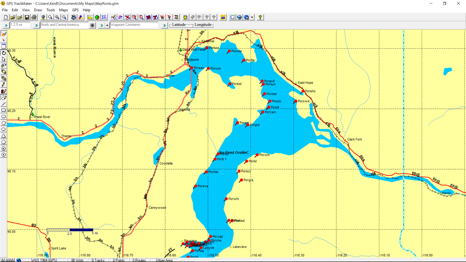
For example, the picture below shows a track from a 2 lap race. You can see that the race started and ended in the west end of the bay and rounded two marks (waypoints) counter clockwise in the middle of the bay. The wind was out of the east and you can easily see the tacks and gybes. By examining the speed of individual segments and angles, you can compare strategies to decide which is faster.
For example, of the two windward beats, the first (two shorter tacks) was actually 6 minutes faster than the second (one longer tack) even though they both covered the same distance and nearly the same routes. If the sail trim was also the same for both beats, then the wind was stronger during the first beat. If the wind was the same for both beats, then the sail trim for the first beat was better than the second.
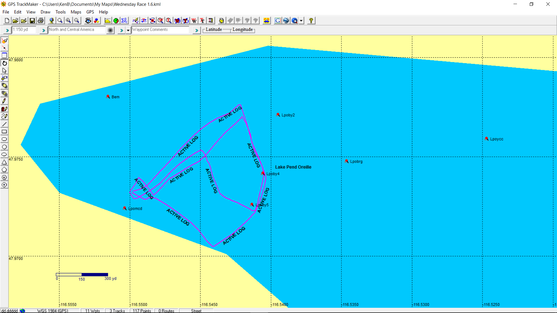
For a free mapping program, check out GPS TrackMaker Free. It’s very good at working with GPS tracks but isn’t as strong at creating routes.
View your data in Google Maps
For a more realistic view of your GPS data, turn to Google Maps. It allows you to upload tracks and waypoints for display over satellite imagery and other types of base maps.
For example, the picture below shows the same track and waypoints as above but displayed over satellite photos.
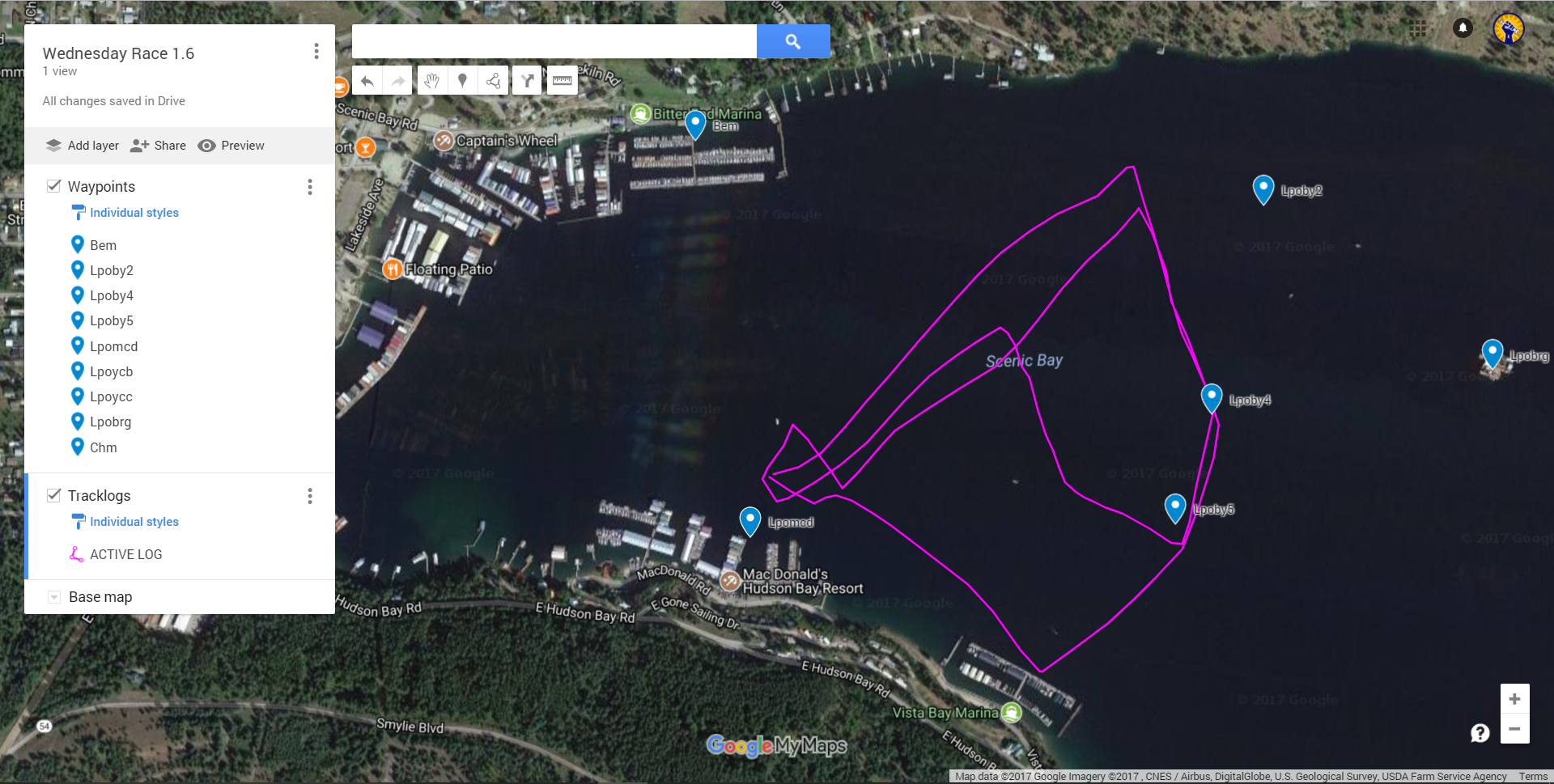
Most mapping software can export data to a format that you can import to Google Maps. You can also save data as individual files in Google Drive for later reference or to share with others. For more information about importing data into Google Maps, see My Maps Help.
Connect older GPS devices to newer PCs
To upload and download data like I’ve described, you need to connect your handheld GPS to your computer. If you have an older GPS device like mine, it probably uses a cable with an old-fashioned DB9 serial port connector. If you have a newer computer, it probably has the newer USB ports and might not have a DB9 jack. In that case, you need a converter in the middle to mediate the connection.
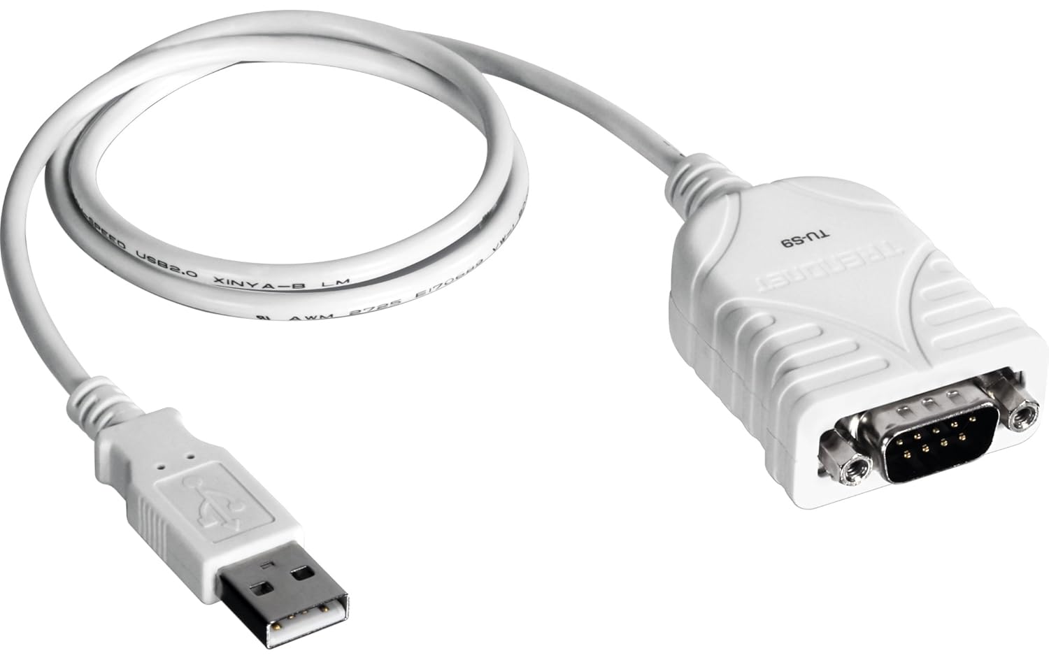
I’ve had good success with the TRENDnet TU-S9. The software installed easily on my Windows 10 notebook and it worked on the first try with no configuring. However, although the combination worked with GPS TrackMaker as shown above, it did not work with all the software that I tried. Newer programs that only support USB connections to your GPS might not work at all. Your mileage may vary as they say.
Getting started

If you’d like to get started in GPS navigation but don’t have a suitable GPS, I recommend purchasing a newer model than mine so that you can take advantage of the many improvements that have been made in recent years. The Garmin GPS 73 is an inexpensive, basic device that has several sailing features that can be helpful.
It’s tack assist feature lets you know when to tack based on whether your boat is getting headed or lifted compared to the boat’s optimal tacking angle. If you race, there’s a virtual starting line feature and a countdown timer. As an alternative, I suggest you consider the Garmin GPS 78. It’s slightly more expensive and has color base maps. However, the screen is too small to show the level of detail necessary for the maps to be very useful.
My last tip is, if you find that you enjoy using a GPS, check out the world of geocaching. Think of it as a global treasure hunt. The best place to start is geocaching.com. It’s fun for the whole family that you can enjoy almost anywhere, anytime, and it will help you to hone your GPS skills.
Would you like to be notified when I publish more posts like this? Enter your email address below to subscribe to this blog and receive notifications of new posts by email. You will also receive occasional newsletters with exclusive info and deals only for subscribers and the password to the Downloads page. It’s free and you can unsubscribe at any time but almost nobody does!

I appreciate this helpful article. Given that most of the GPS features described here can now be found on free or low-cost phone apps, I’d be interested in your thoughts, as a fellow penny pincher, on whether it’s worth the cost to purchase a dedicated GPS device for day sailing and coastal cruising.
Good question, David.
Yes, there are some excellent apps for phones and tablets. I have an older Android tablet that is unsupported now and the battery won’t hold a charge, so I leave it plugged in and just stream music with it now. Despite working in the computer software industry for my day job, I don’t own a cell phone. I don’t really need one and the non-conformist in me is resisting getting one. My life is so connected already that I don’t want another device to maintain, pay for, and distract me from more important things.
My experience with mobile devices has been that the screens aren’t bright enough to read from a distance in direct sunlight. Handheld GPS devices are designed with high contrast screens that stay very readable in most lighting conditions.
That said, if you can make your mobile device work for you, go for it! If I had one that I liked, this post would probably be about phone apps instead 😉
I have an old Magellen Colortrak and have considered using it on Simran when she’s back on the water. One challenge I see is most of the tools you mention for mapping and track review require a PC. Have you explored an approch using a mobile operating system? (I have Android devices all around that could be repurposed for visual presentation of map and GPS data, having ditched the PC world upon retiring!) Maybe you have seen good resources on the topic that cover Android devices?
Thank for the great article(s)!
As I just said in my reply to David’s question, I do have an older Android tablet but I don’t use it much anymore. It doesn’t have a GPS built in, so I didn’t explore those kind of apps for it. I’m sure there are some good ones out there. If you discover one that you really like, feel free to mention it here for others to try.
And if I do relent and go over to the dark side, I’ll be sure to post a roundup of sailing apps on this site.
Thanks for the interesting article … for the good of the group, one might consider the DeLorme Earthmate PN-60 handheld GPS. It has an SD card slot that supports Navionics marine charts. I added one as a back-up to my boat’s chart plotter … a small display, but nice to have actual charts in your hand!
Great info,thanks.